a b c d e f g h i j k l m n o p q r s t u v w x y z #

Gorje

gorje_kat.jpg

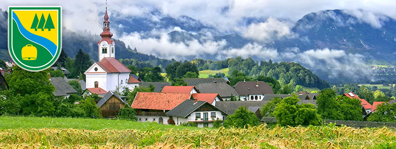
Gorje or gorjanski kot (highlands corner) is the name for a group of 11 villages and settlements, and represents the area adjacent to Bled, Bohinj White, Jesenice, Kranjska Gora and Bohinj.
The most recognizable landmarks of Gorje are the Pokljuka gorge, through which also leads Slovenian Geological Trail and Vintgar Gorge - 1600 m long gorge, through which flows the wonderful greenish Radovna river with its pools, waterfalls and rapids. Gorge, which was officially opened in 1893, ends with a waterfall Šum, which is considered to be the largest river and free-falling waterfall in Slovenia.
Gorje however offers so much more and invites guests with wonderful views of the Karavanke, archaeological finds, which date back to the time of the Stone Age, historic homesteads and holiday resorts.
And on top of it all, you will love the comfortable private accommodations and delicious, genuinely homely food.

Občina Gorje

Občina Gorje

Gorje ali gorjanski kot pojmujemo skupino vasi in zaselkov, oddaljenih kakih 5 kilometrov od Bleda v smeri proti Pokljuki, dolini Radovne in Mežakli. Gorjansko območje sega od roba blejskega kota v nadmorski višini 603 m do malega Triglava 2700 m nadmorske višine.

Gostilna PR’ JAGRU – Zatrnik

Gostilna PR’ JAGRU – Zatrnik

V prijetnem okolju nedaleč od Zgornjih Gorij – na Zatrniku, vas osebje Gostišča Pr`Jagru vabi na prijetno druženje, kjer lahko poizkusite slovenske jedi: enolončnice, kmečki krožnik, divjačinske jedi, odojek, jedi z žara, ajdove žgance, štruklje in domači kruh.

What's POI map?

POI map is a tourist information map, that can be found in many tourist points troughout Slovenia.

Read more ...

Newsflash

All our advertising partners get free advertisement for one year on our web page!

All rights reserved! © 2012 POI.si - TakeHigher web design

NOTE! This site uses cookies for optimizing your browsing experience.

If you not change browser settings, you agree to it.

I understand